Integrated Remote Sensing and GIS for Calculating Shoreline Change in Rokan Estuary
DOI:
https://doi.org/10.18502/keg.v1i1.491Abstract
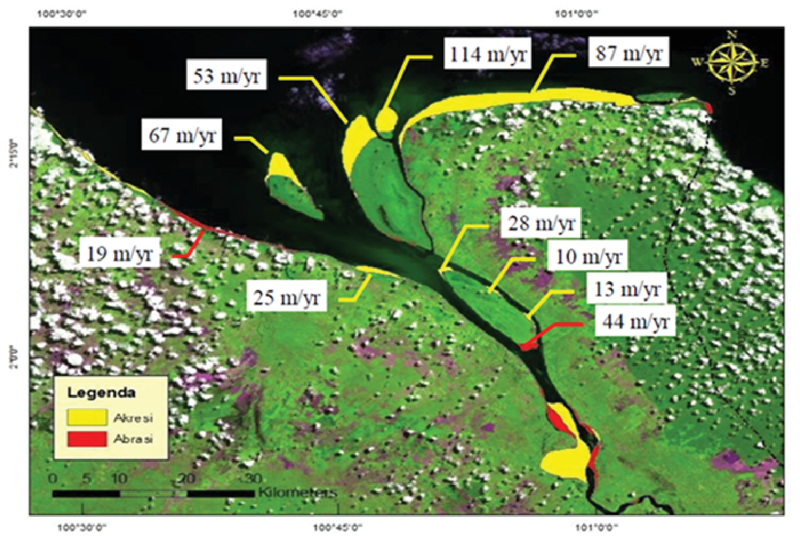
This paper presents an application of satellite remote sensing techniques to detect and to analyze the spatial changes as well as quantify the shoreline change in Rokan estuary, Riau Province, Indonesia. Coastal zone of Rokan estuary, a place through which Rokan River flows into Malacca Strait is dynamically changed because of the hydrodynamic nature and high sediment transport in downstream of Rokan River. By integrating modern techniques of remote sensing and GIS (Geographic Information System), the rates of shoreline change would be easily and quickly determined for a regional area. Landsat satellite images were used with a combination of histogram thresholding and band ratio method for shoreline change detection for last 14 years from 2000 to 2014. The shoreline data then were adjusted for serving as an input for GIS tool to estimate the erosion and deposition rates. The statistical method called as LRR (Linear Regression Rate) in DSAS (Digital Shoreline Analysis System) was used in this study. The results of this study present shoreline changes map of Rokan estuary for last 14 years. Quantitatively, the shoreline of Rokan estuary is dynamically changed over a time because accretion rate is very high. The accretion rates in Halang, Barkey, and Serusai Island within 14 years are 67 m/yr, 53 m/yr, and 114 m/yr respectively.This occurs becauseReferences
T. P. T. Pham, H. D. Duan, and D. Van To, Integrated remote sensing and GIS for calculating shoreline change in Phan-Thiet coastal area, Int. Symp. Geoinformatics Spat. Infrastruct. Dev. Earth Allied Sci., 1–6, (2008).
T. Van and T. Binhz, Application of remote sensing for shoreline change detection in Cuu Long estuary, VNU Journal of Science, Earth Sciences, no. 25, 217–222, (2009).
, A. Ghorbanali, N. Nouri, et al., Coastline change detection using remote sensing, Int J Environ Sci Technol, 4, 61–66, (2007).
H. M. El-Asmar and M. E. Hereher, Change detection of the coastal zone east of the Nile Delta using remote sensing, Environ Earth Sci, 62, 769–777, (2011).
E. Thieler, et al., (2009), Digital Shoreline Analysis System (DSAS) version 4.0 — An ArcGIS extension for calculating shoreline change.
S. Sutikno, Rate of Shoreline Change Analysis of Bengkalis Coast Using Satellite Imagery Data, The 31st Annual Conference of Indonesian Association of Hydraulic Engineer, 616–625, (2014).
W. P. Beach, A. S. Genz, C. H. Fletcher, R. A. Dunn, L. N. Frazer, and J. J. Rooney, The Predictive Accuracy of Shoreline Change Rate Methods and Alongshore Beach Variation on Maui, Hawaii, J Coast Res, 23, 87–105, (2007).
R. S. Kankara, S. C. Selvan, B. Rajan, and S. Arockiaraj, An adaptive approach to monitor the Shoreline changes in ICZM framework: A case study of Chennai coast, Indian J Mar Sci, 43, (2014).
in W. Rahmansyah and Rifardi, “Suspended Solids in Rokan River Estuary, Riau Province, Indonesia, 1–14, Repos. Univ, Riau, 2014.
S. Bagli and P. Soile, Morphological Automatic Extraction of Pan-European Coastline from Landsat ETM Images 5th Int. Symposium on GIS and Computer Cartography for Coastal Zone Management, Integrating Information in Coastal Zone Management, Genova, August 2003.